Skip to content

Cookies 🍪

This site uses cookies that need consent.

Learn more

Zur Powderguide-Startseite Zur Powderguide-Startseite

Language selection

Search PowderGuide

WeatherBlogs

WeatherBlog 14 2017/18 | Warm front and uncertain future

Today sun tomorrow warm front

by Lea Hartl 02/14/2018
Intermediate high pressure with residual clouds yesterday in Tyrol.

Intermediate high pressure with residual clouds yesterday in Tyrol

.

LH
Today, Wednesday, will be very sunny for the most part thanks to the influence of intermediate highs, and any remaining hillside clouds should clear quickly. Thursday will be cloudy with the arrival of a warm front from the west. In the western Alps, it will probably be cloudy from the morning onwards, while it will remain clearer in the east in the morning.

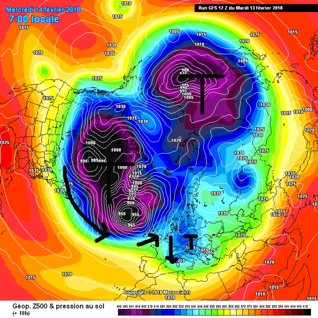
As is so often the case, the warm front will bring precipitation, a rise in temperature and therefore some concern about the snow line. It will tend to be warmer in the west than in the east with rain up to around 1400m within the realms of possibility. Particularly in the inner Alps, the snow line may also be significantly lower in the west due to inversion: If the snow line is actually at 1400m, for example, but the inversion upper limit is also at around 1400m, it will sometimes snow all the way down a valley, while a few kilometers further on, where the inversion in the valley has already been cleared out by the front, it will rain up to high altitudes.

The snow from the aforementioned warm front will probably remain below alarm-worthy amounts. The main ridge in western Switzerland will probably get the most. On Friday, it will continue to snow lightly in the north and remain rather cloudy. The southern slopes of the Alps will be favored by the weather during this episode. The weather here will be comparatively bright on Thursday and Friday. Saturday still looks rather unsettled, but Sunday will be quite sunny from today's perspective.

WeatherBlogs
presented by

Medium-term

The medium-term outlook is similarly uncertain and difficult to predict as the snow line for the upcoming warm front, albeit for different reasons. The snow line depends on the timing of the front and local topographical effects, in particular the formation of cold air lakes (inversions) and possible precipitation cooling in narrow valleys. The outlook for next week and beyond, on the other hand, depends on very large-scale pressure structures. The polar vortex (as already mentioned last week) currently has two distinct low pressure centers, one roughly in northeastern Canada, the other in eastern Siberia, and is therefore not a "real", intact polar vortex, but a split something that confuses the weather models.

For next week, there are signs of an Atlantic block matching the split polar vortex, i.e. a high in western Europe blocking the westward drift. This in turn could result in longer phases of the same weather - but it is still unclear whether this means longer phases of winter with snow and cold, sun and cold, or rather a few mild days or changeable borderline weather. In any case, the possibility of a wintry second half of February is a given. Here is a nice model comparison and further explanations.

Intermediate high pressure with residual clouds yesterday in Tyrol.

Intermediate high pressure with residual clouds yesterday in Tyrol

.

LH

Miscellaneous

The DWD provides an overview of contrails and the complicated influence of man-made clouds on the climate in the Topic of the Day section. Nevertheless, contrails are still not chemtrails.

MeteoSwiss has some interesting statistics that show that in the last 20 years or so, more and more monthly heat records have been set in Switzerland, but hardly any cold records.

This article has been automatically translated by DeepL with subsequent editing. If you notice any spelling or grammatical errors or if the translation has lost its meaning, please write an e-mail to the editors.

Show original (German)

Related articles

Comments

WeatherBlogs
presented by