Skip to content

Cookies 🍪

This site uses cookies that need consent.

Learn more

Zur Powderguide-Startseite Zur Powderguide-Startseite

Language selection

Search PowderGuide

WeatherBlogs

WeatherBlog 24 2016/17| April weather

Where does the April weather come from?

by Lea Hartl 04/11/2017
WeatherBlog on vacation, April overseas

WeatherBlog on vacation, April overseas

LH
LR
This year, the weather is once again following the perceived trend of "bathing weather at Christmas, snow at Easter" and is generally "april" for the Easter weekend. Why is it often so unstable in April?

Outlook

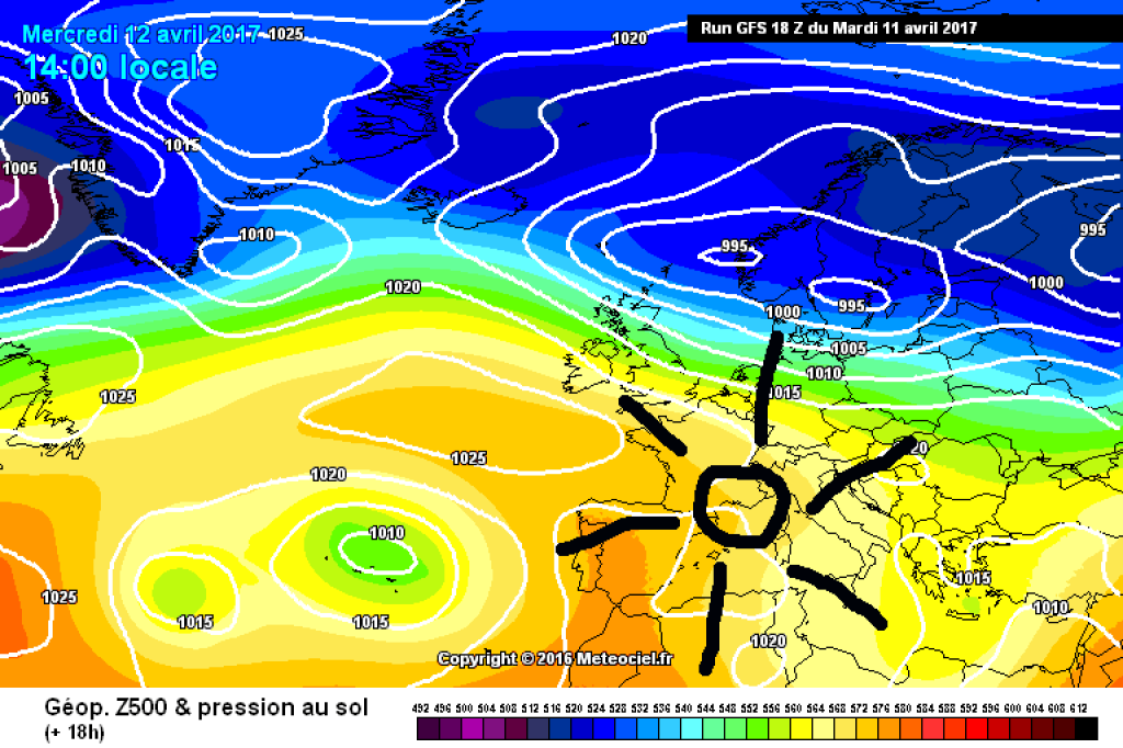
Between yesterday's and tomorrow's disturbance, intermediate highs will dominate today, Wednesday. The sunshine will hardly be clouded over the entire Alpine region, with only a few high clouds to be expected in the east. Tomorrow (Thursday), a cold front from the northwest will reach the northern eastern Alps, bringing denser clouds and widespread showers. The weather will remain more favorable in the south, but the tendency for showers will increase here as well. Friday will be clearer everywhere, but still with the potential for the odd shower in variable cloudiness. From today's perspective, Easter weekend looks rather cloudy, wet and relatively cool. This trend is likely to continue into next week.

April does what it wants

Or rather: April does what large-scale, radiation-related temperature differences want. In spring, the sun gains strength as its position increases and warms the land and water masses of the mid and high latitudes, which have cooled over the winter. However, land and water do not warm up at the same rate. Water has a high specific heat capacity and therefore needs more energy to warm up as much as sand, for example. The specific heat capacity of water is 4,128 joules per kilogram and Kelvin, which means it takes 4,128 joules to heat one kilogram of water by one degree. That is about five times as much as you would need for sand. So when the spring sun shines on the oceans and continents, the latter warm up quite quickly, while the former lag behind.

Typical large-scale weather patterns for April weather as you might imagine are "Trough Central Europe" and "cyclonic northerly situation" - both weather situations in which polar air masses reach Central Europe via the Arctic Ocean, as is the case with the northwesterly situation forecast for the weekend.

WeatherBlogs
presented by

The polar air is enriched with moisture on its way across the sea and, coming from the far north, is still quite cold. When it reaches the mainland, it is significantly warmer on the ground than over the sea due to the already spring-like strong solar radiation and because of the story with the specific heat capacity (you learned all this at school at some point). This creates a strong vertical temperature gradient: it may already be 10 or even 20 degrees on the ground, but the frosty polar air is spreading in the middle troposphere. This type of stratification is very unstable and favors heavy showers and thunderstorms with everything that goes with them (sleet, heavy rain, etc.). Between the showers, it always clears up again (convection) and while you were still looking for Easter eggs in the driving snow in the morning, the sun suddenly shines in the afternoon.

In winter, the power of the sun is not enough to heat the ground sufficiently and in summer, advances of polar cold air are rarer, so this particular type of changeable weather is mainly reserved for spring. Convective showers and heat storms, as we know them from summer, are often dynamic (caused by a special weather situation) and not purely thermal (cold-warm contrast), like the typical April weather.

WeatherBlog goes on summer break

The WeatherBlog is ready for the island or the lonely mountain hut and is actually already on vacation, so this heralds the summer break. The ski season is of course far from over and if anything particularly interesting happens again, the WB will of course be in touch. Otherwise, we'll be back in the fall when a new winter starts.

500hPa geopotential and ground pressure today (Wednesday): Intermediate high pressure in the Alpine region.

500hPa geopotential and ground pressure today (Wednesday): Intermediate high pressure in the Alps.

meteociel.fr

This article has been automatically translated by DeepL with subsequent editing. If you notice any spelling or grammatical errors or if the translation has lost its meaning, please write an e-mail to the editors.

Show original (German)

Related articles

Comments

WeatherBlogs
presented by