Skip to content

Cookies 🍪

This site uses cookies that need consent.

Learn more

Zur Powderguide-Startseite Zur Powderguide-Startseite

Language selection

Search PowderGuide

WeatherBlogs

WeatherBlog 5 2017/18 | Between a foehn storm and record precipitation

Weather chaos with Ana a.k.a. Yves

by Lea Hartl 12/12/2017
When the weather really gets going, meteorologists' hearts always beat a little faster. This week's WeatherBlog therefore includes a summary of the rather spectacular weather of the last few days and, of course, a brief outlook.

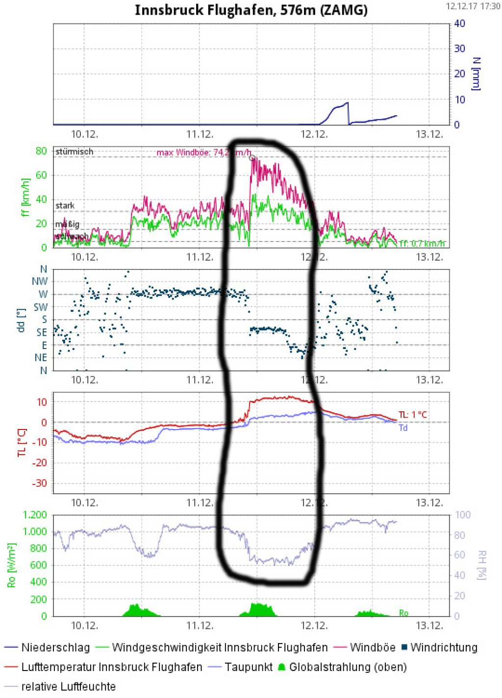
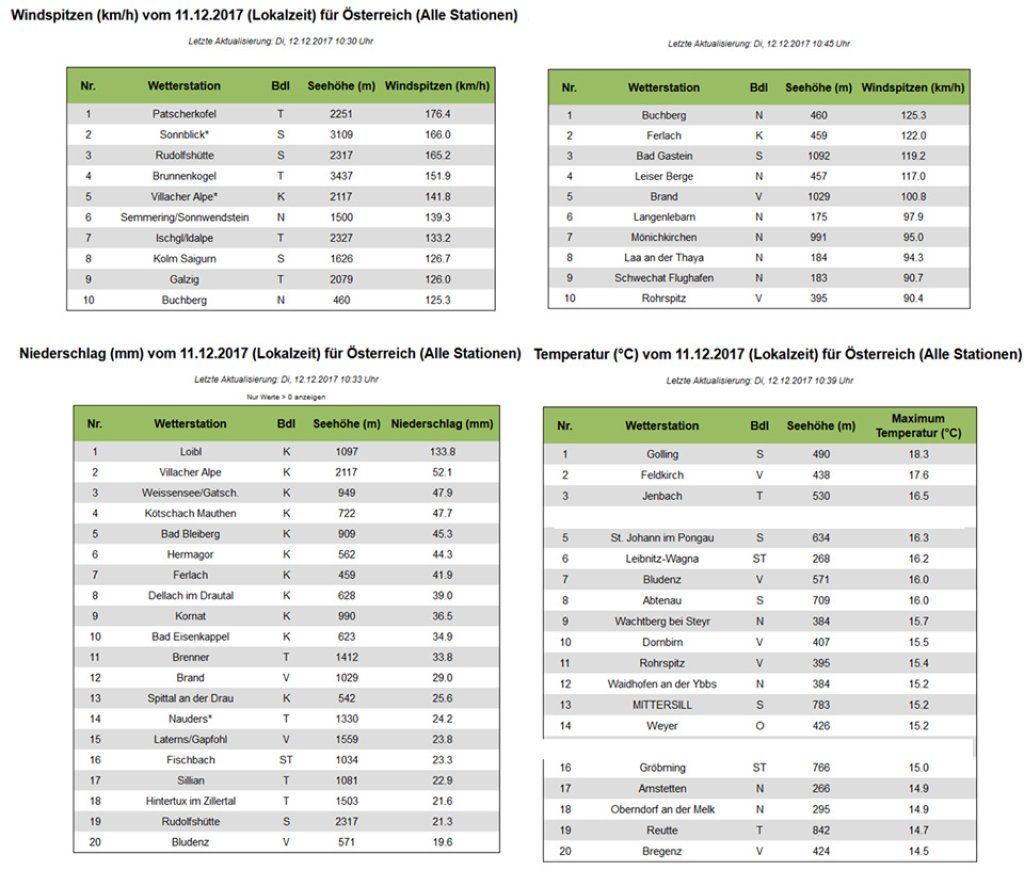
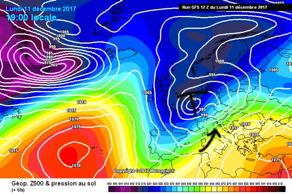
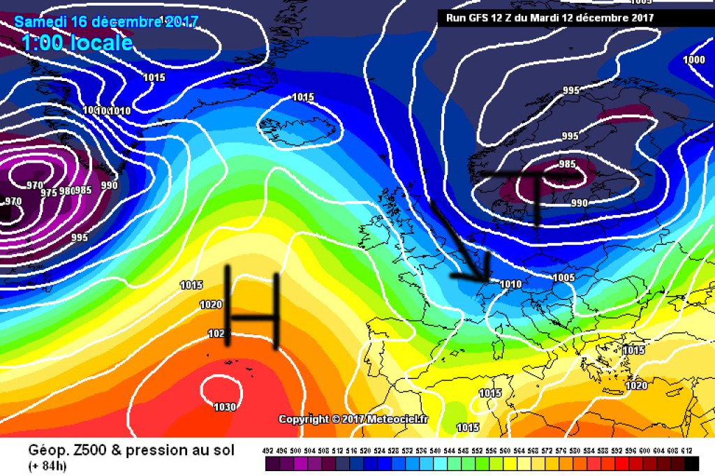
Mainly responsible for the extremely turbulent weather of the last few days was a low (Ana a.k.a. Yves, depending on who you ask) with a core in the north of France. The core pressure of Ana/Yves was quite low for a low pressure system at these latitudes. This and the position of the low created a very strong pressure gradient between the Mediterranean region and Central Europe, which in some cases produced extreme foehn effects and boosted the warm air advection from the south.

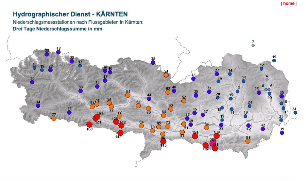
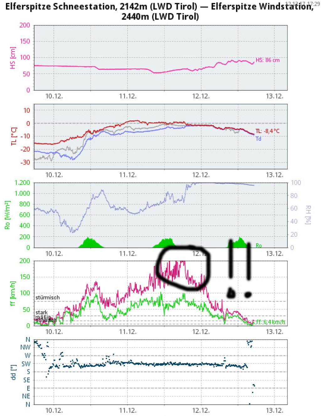
On the southern slopes of the Alps, the southwesterly pressure of Ana/Yves caused more than considerable amounts of precipitation over a fairly wide area, with the snow line rising significantly from west to east. While some French measuring stations received well over 1 m of fresh snow, in some cases closer to 2 m, comparable amounts of precipitation fell as rain further east up to high altitudes. However, some avalanche warning services in the Eastern Alps also reported 60 cm to over a meter of fresh snow in the high mountains and issued a corresponding level 4 on the main ridge. In France, level 5 was issued in places.

Severe flooding occurred in the Emiglia Romana. Various dams broke on the Enza, a tributary of the Po. Some villages are under water. Around 1,000 people were evacuated from the worst-affected town of Lentigione.

WeatherBlogs
presented by

In the north of the Alps, the Föhn was the defining element of the last few days, both in terms of wind and temperature. In many classic foehn spots, such as Innsbruck, the "battle" of the air masses was easy to observe.

On Sunday and Monday, the foehn demonstrated very impressively that it can completely change the weather from one moment to the next and locally on a very small scale if it feels like it. Some people were asked not to leave their homes in the already susceptible Föhn corridors. Where the Föhn did not pass through, it was calm and much colder.

The arrival of the Föhn on Tuesday evening is clearly visible in the station data from Innsbruck Airport: The wind direction turns from west to south, the wind speed increases markedly, the temperature jumps up by 10 degrees almost abruptly and the humidity plummets. The highest wind speeds in Tyrol were measured on the Elfer in the Stubai Valley, with peak gusts reaching 236 km/h here. This corresponds to wind speeds in a category 4 hurricane and is far beyond "uncomfortable".

With the collapse of the Föhn on Tuesday, it became calmer again and the temperature almost dropped back to pre-Föhn levels. The precipitation in the south slowly subsided, but light snowfall set in in the north.

What's next?

Today, Wednesday, is looking quite clear in many places. Anyone using the weather window for skiing should consider what wind, temperature fluctuations and fresh snow mean in terms of avalanche risk.

The WeatherBlog expects an early report from our colleague Orakel regarding developments on Thursday and Friday. The "Trough Central Europe" pattern, which has been seen several times now, will enter the next round and bring another load of fresh snow to the Western Alps. The weekend will remain changeable and cool, with the east tending to be friendlier than the west and the south generally favored by north föhn.

There are signs of moderation and high pressure for next week. However, the WeatherBlog does not intend to go out on a limb with a Christmas forecast just yet...

Photo gallery

This article has been automatically translated by DeepL with subsequent editing. If you notice any spelling or grammatical errors or if the translation has lost its meaning, please write an e-mail to the editors.

Show original (German)

Related articles

Comments

WeatherBlogs
presented by