Skip to content

Cookies 🍪

This site uses cookies that need consent.

Learn more

Zur Powderguide-Startseite Zur Powderguide-Startseite

Language selection

Search PowderGuide

WeatherBlogs

WeatherBlog 9 2017/18 | Hail of iguanas and boiled bat brains

Extreme weather worldwide

by Lea Hartl 01/09/2018
It's not often that international weather reports dominate the evening news. If it does, there is usually not much else happening, or the weather has a massive impact on many people's everyday lives, for example in the form of extreme temperatures, as recently seen in the eastern USA and Australia, or masses of snow, as is currently the case in the Western Alps.

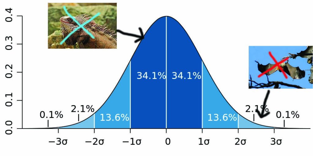
When we talk about extremes of any kind, we always implicitly refer to a certain understanding of normality, which is not met in this case. In the case of weather, this is based on measured values from the past. Assuming you have measured and recorded the maximum temperature at location X every day for 100 years, you have 365 x 100 data points (we will ignore leap years as an exception), or 100 reference values for every day of the year. You can therefore compare the maximum temperature of January 10th with the maximum temperature of 99 other January 10ths. If you count how often a certain maximum temperature has occurred on January 10th in the last 100 years, you will find that most January 10ths have the same temperature with a few degrees of variation. In some years, however, January 10th was colder or warmer than the temperature range covered by this fluctuation margin. The less frequently a certain temperature occurs, the further we move into the outer areas of the Gaussian bell curve, which describes our normally distributed temperatures. There was something like this in math class at some point.

When it comes to weather issues, this curve is used as a guide for extreme events. If the temperature is below a certain value on 10 January in one out of 100 years, it is often referred to as a "century event", although it should be emphasized that such assessments are difficult to make if only 100 years of data are available. It would be better to say that a 100-year event is the maximum temperature that has only been exceeded 9 times on January 10 in the last 1000 years.

The bell curve moves outwards only very slowly towards zero, i.e. it makes room for such and even rarer events. Many risk assessments, such as those used for hazard zone plans or by insurance companies and the major reinsurers, operate in this range of rare to almost never expected events.

Current situation

Apart from the snug stochastics, headlines such as "Lizard blizzard: iguanas rain from trees" and "Hundreds of boiled bats fall from sky" are also good indicators of extreme weather. And that brings us to the current weather!

The boiled bats fell victim to a heatwave in Australia. A temperature of over 47°C was measured in Sydney on January 6 (as a reminder: it is currently summer in Sydney). The last time it was similarly hot was in 1939, so it could be argued that boiling bat brains in Australia is roughly an 80-year event, although as mentioned above, better data would be needed to definitively establish this.

WeatherBlogs
presented by

In Florida, on the other hand, it rained iguanas (or hail, iguanas are one of the solid types of precipitation), as cold-blooded animals become lethargic at low temperatures and fall out of the trees where they normally like to hang out in an unfavorable way for them and any passers-by. Unlike bats, they recover if the cold does not last too long and they are not run over by a golf cart beforehand.

The cold snap in the eastern USA and Canada has been going on for a while. In the past few days, a strong nor'easter has been added to the mix, which not only caused heavy snowfall in the large, more northerly coastal cities and brought traffic there to a standstill, but also produced an impressive 0.25 cm of snow in Florida, bringing the iguanas to a standstill in particular. The last time it snowed there was 29 years ago, so snow in Florida is an approximately 30-year event. Iguana hail, on the other hand, occurs surprisingly often and is more of a 5-year weather phenomenon. (Iguanas are unwanted, illegal immigrants in Florida, which actually come from even warmer areas in South and Central America and do not cope well with Florida's harsh winters). The big cold in America is coming to an end, which is probably not only pleasing for the iguanas.

The following pressure patterns are responsible for the equally impressive snow situation in the western and southern Alps, as well as on the Iberian Peninsula: A high over Eastern Europe and Scandinavia has been blocking the westerly drift driven by the North American cold air for a few days and Atlantic lows have to move out of the way or cannot get any further. The current low of this type is mainly hanging off the British Isles, but has managed to send a small offshoot as far as Spain. There is no reptile problem there, but snow chaos on the feeder highways from Madrid.

Thanks to the warm Mediterranean, the Spanish low pressure system can accumulate moisture and, as it reaches far south, also Saharan dust. The moisture was dumped in the form of massive snowfalls in the western and southern Alps. Here too, the weather is causing problems (and skier hype and viral videos of people having to dig out their car completely submerged in snow). Zermatt can no longer be reached by road, and the 13,000 trapped vacationers are being kept happy with free cheese fondue. Saas-Fee is also still cut off, as are Breuil-Cervinia and some smaller communities in Switzerland and the French-Italian border region. In Sestriere, an avalanche made it into the stairwell of an apartment building, but no one was injured. The avalanche danger in the most affected areas has been between 4 and 5 in recent days and remains very high.

In the northern and eastern Alps, the picture was completely different: warm, foehn-like T-shirt weather with only minor interruptions due to rain showers and distant thunder. Winter thunderstorms, which are very rare in high winter, could be observed in many places, especially yesterday towards the main ridge.

Outlook

Today, Wednesday, the general chaos will die down relatively unspectacularly. The western Alps can start digging out their roads and the northern and eastern Alps will slowly have to put on a sweater again. The Spanish low drifts eastwards into the Mediterranean and hangs around there for a few days with a very weak gradient. This turns off the Föhn wind and it gets colder. The relatively sunny, relatively unexciting weather now accompanies us for a while. In the lowlands, fog is a common occurrence, while on the mountains it will remain fairly clear until the weekend with a brief interruption and unproductive snowfall in the north tomorrow (Thursday).

Far into the future (middle of next week), the model glass sphere indicates a possible change in the general weather situation from a "weird, half-baked swamp" to the northwest. The Azores High will push northwards and the Icelandic Low will have to give way. This constellation would give the Alps a moist, cool NW flow. We can look forward to this and enjoy the abundance of snow in the west with due caution until then.

Photo gallery

This article has been automatically translated by DeepL with subsequent editing. If you notice any spelling or grammatical errors or if the translation has lost its meaning, please write an e-mail to the editors.

Show original (German)

Related articles

Comments

WeatherBlogs
presented by