

In addition to the skiing ability of the winter sports enthusiasts involved, the avalanche danger determines which slopes can be skied on at any given time. Werner Munter's motto "The steeper the better, the faster the avalanche" puts it in a nutshell: We freeriders have to adapt our choice of terrain to the avalanche situation.
The avalanche danger determines which tours and descents are possible
The higher the avalanche danger, the less favorable the snowpack is and the more defensive the terrain must be chosen. In short: low avalanche danger and favorable snow conditions mean: steep terrain can be chosen. High avalanche danger and unfavorable snow conditions mean: I limit myself to moderately steep or even flat terrain.
3x3 filter and reduction methods as a basis for decision-making

The various risk check methods used today go back to or build on the revolutionary work of avalanche expert Werner Munter. Today, these risk checks are the basis for sensible decisions by risk-conscious winter sports enthusiasts who do not want to deal with the avalanche problem in the style of Russian roulette. The best-known methods are: 3x3 filter, reduction method, SnowCard, golden rule and beer mat quick check. If you are not yet familiar with these methods, you can find a brief description of these risk check methods as a link.
The 3x3 filter method is particularly suitable for preparing tours and freeride days. This assesses the factors "conditions" (avalanches, snow, weather), "terrain" and "people" and enables simple but professional and risk-optimized planning. In addition, the factors naturally influence each other and must harmonize with each other in the final planning.
The human factor

Of course, a tour must be adapted to the physical and mental abilities of the group. As self-evident as this statement is, misplanning is disastrous. Even the most leisurely tour can turn into a disaster if one member of the group has problems in a key section, gets scared on the ridge or runs out of energy at the end.
The weather factor

The weather must also suit the tour. Easy tours not far above the tree line can be done in bad weather if the avalanche situation is favorable. However, as soon as the terrain requires a more difficult orientation or the avalanche situation demands that you can assess the surrounding slopes, the bad weather tolerance drops considerably. As with all other factors, the weather must therefore suit the conditions and planning.
The avalanche factor
1. the current and expected avalanche warning level for the area in question.
2. the maximum slope gradient of the descent or tour to be skied. Attention: the higher the avalanche danger, the greater the avalanche danger of the surrounding terrain must be assessed in the danger assessment. Due to the possibility of remote triggering, the entire slope section must then be taken into account.
3. Also very important for assessing the risk of a descent or tour is its exposure(s), i.e. the direction in which the slope(s) are inclined.
4. The number and ability of the winter sports enthusiasts involved.

Avalanche danger and snowpack information
The avalanche warning level describes the general danger of avalanches. The additional information, i.e. the "small print", reveals which slopes are more favorable and which slopes are particularly risky.
Slope gradient, slope exposure and terrain formations
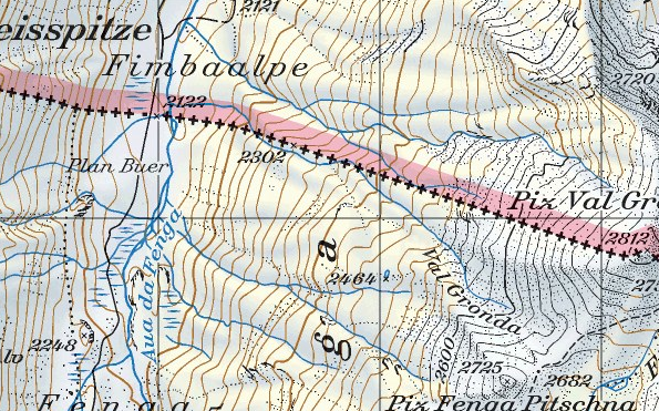
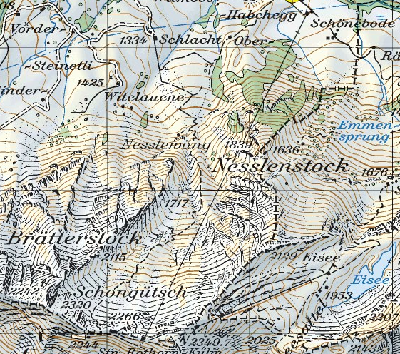
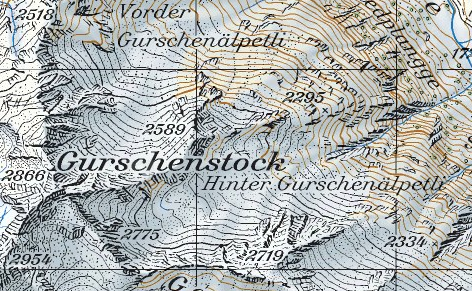
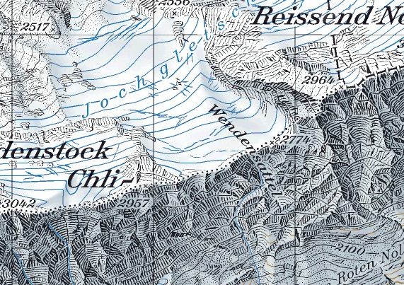
The slope gradient can be measured or estimated in the terrain, but then it is too late to plan a tour in advance. Topographical maps on a large scale (1:25,000) have proven particularly useful for tour and freeride planning. With the help of such maps, it is easy to reliably determine the slope gradient, slope shape and exposure of almost any section of terrain. How does this work? You can find an introduction to measuring slope inclination on the map here...
The size of the group
The more winter sports enthusiasts there are on the snowpack at one point, the higher the probability of triggering an avalanche. For this reason, large groups are not only difficult to organize because you either constantly get in each other's way or have to wait a lot, but also because the probability of triggering an avalanche also increases. This is particularly true in unfavorable avalanche conditions, whereas in low avalanche danger (level 1) there is little reason not to go on a backcountry excursion as a larger group.

The terrain factor
Terrain types
Every freerider should know a few important terrain types. In addition to recognizing typical terrain traps, it is also important to recognize the particularly suitable ones, the terrain treats, so to speak, in advance in order to decide whether a tour or an area is particularly worthwhile.
Danger spots
Individualized steep slopesIndividualized, extreme steep slopes that are steeper than 39° are among the particularly critical terrain forms. Due to the lack of pronounced terrain structures, the snow cover is weakly supported. Large avalanches often occur here, especially at high danger levels.
Terrain traps: Troughs, ditches, depressions, flat sections
Deeply cut ditches, pronounced troughs and depressions as well as flat sections below steep slopes can become deadly traps. Even comparatively small avalanches can lead to very deep burials, especially in hollows or streams.
Waiting points should never be chosen on flat areas at the end of steep slopes, as there is very little chance of escaping if an avalanche is triggered from above.
Channels
Many slopes, especially in rocky terrain, are criss-crossed by channels and ridges. While the rock formations are often covered with little or no snow, there is often a lot of drift snow in the gullies, meaning that they should always be treated with caution, especially after fresh snowfall under the influence of wind. Caution: gullies are avalanche paths.

Steep slopes behind terrain cuts (saddles)
Steep slopes behind terrain cuts and saddles in the lee (slipstream) are among the typical places where avalanches are triggered and winter sports enthusiasts are buried. The terrain cuts often cause a jet effect, which means that large amounts of drift snow are often deposited on the lee side of such saddles.
Steep slopes with rockfalls
Steep slopes with large rockfalls are risky and unfavorable: the snow cover is barely supported and can therefore be disturbed more easily. There is also the risk of falling in the event of an avalanche or a fall.

Glaciers
When freeriding in the high mountains, you often find yourself in glaciated terrain. In winters with little snow and generally in early and high winter, the crevasses are often only thinly covered with snow and the risk of falling from crevasses is high. Local knowledge is a decisive advantage here. If you know the positions of the crevasse zones, you can usually make good progress on glaciers without too much risk, provided you have good visibility. Caution: Glacier tours and descents require not only the appropriate equipment (rope, harness, carabiner, slings, ice screw) but also the appropriate know-how for crevasse rescue.
Invisible terrain
In extremely steep terrain, most descents are not visible over their entire length, which makes navigation considerably more difficult and also makes it very difficult to coordinate within the group.
Particularly rewarding and risky terrain
Cuped terrain
Cuped terrain usually offers good opportunities to find comparatively favorable ascent and descent routes, even in a tense avalanche situation. However, you should be aware that the slope gradient and exposure can change constantly over a very small area and that favorable and dangerous areas can be directly adjacent to each other. Visually, such terrain gives the deceptive impression of being avalanche-proof. However, even medium-sized avalanches can wash over stepped or hummocky terrain and then the hollows can become a deadly trap.
Ridges
There is almost always significantly less snow on ridges than in hollows and gullies. Therefore, you will often find much less risky ascent and descent options here, especially in tense avalanche situations. However, the downhill fun is often rather limited there.
A special situation is very snowy winters, such as the current winter of 2012: as the snow cover on the ridges is less thick, any existing weak layers in the snow cover in the area of the thin snow cover can be disturbed more easily and avalanches can be triggered as a result. In the area of very thick snow cover, low-lying weak layers can usually hardly be disturbed by winter sports enthusiasts. However, such special situations are usually mentioned in the avalanche situation report. See the "small print".

Extensive, moderately steep terrain
Extensive, moderately steep terrain can often be skied even in critical avalanche situations, provided it is not in the run-out or catchment area of dangerous avalanche slopes. Perfect terrain for simply skiing at full throttle or for a relaxed ascent. Such slopes are not for adrenaline freaks, but they are totally relaxing, and not just because the avalanche risk is usually much more relaxed here...

Flat, widening slopes
Steep slopes that widen and flatten out are more favorable than slopes or couloirs that end in trenches or narrow passages, for example (see the section on terrain traps).
In the event of an avalanche, the avalanche deposit is likely to be less powerful at the flat base of the slope, so that buried victims are often buried less deeply or only partially buried here, or even not buried at all.

"Safe spots" and "islands of safety"
Even if the word "safety" should be used with the utmost caution in the winter mountains, the term at least reveals the criteria that should be used to select stopping points or assembly points. You still see too many winter sports enthusiasts stopping to wait on risky slopes. Good places to stop can be found on elevated summits, in the shelter of large rocks or on ridges at a distance from avalanche-prone terrain.
Guide books and (special) maps as a planning tool
Descriptions from ski touring or freeride guides and various special maps such as the Freeride Maps or the Swiss Ski Touring Maps are a particularly useful preparation tool for ski tours. Well-researched guide literature not only offers great ski tour suggestions, but also provides valuable information on danger spots and tips on special delicacies.
The freeride maps, which have been available for several years, roughly mark the terrain that is suitable for freeriders in the respective areas. Ski touring maps, e.g. the highly recommended Swiss 1:50,000 ski touring maps from Swiss Topo, not only offer the legendary quality of the Swiss maps, but also include almost all ski tours that are also described in the tour guides of the Swiss Alpine Club (SAC).
Have fun and success planning your toursThe Mountain Mastery Crew