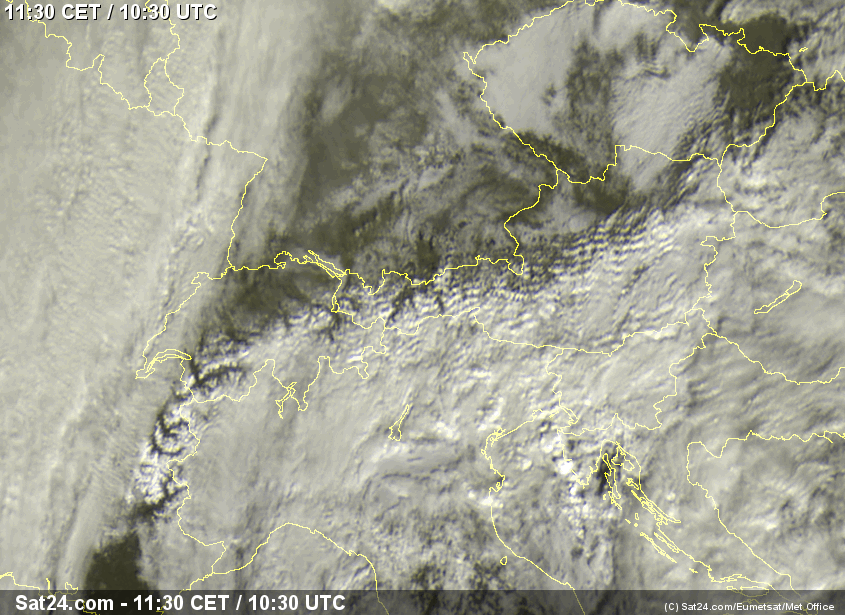
PowderGuide über-user Tobi asks: how do such pronounced southern winters or, last winter, northern winters come about? I'm aware that there is a certain tendency towards conservation. But the fact that it's always so extreme, like this winter, is amazing to me.
Tobi has already asked the question about southern and northern winters several times and I've successfully avoided it so far because I find it difficult to give an answer. The first difficulty is what exactly is meant by a southern or northern winter and how to define "repeatedly" and "soooo extreme" in concrete terms.
2012/2013
In the winter of 2012/13, the Austrian avalanche warning services counted "around 15 Adriatic lows". In combination with continental cold air, these led to "balanced to above-average amounts of snow" in the south of Austria. On the main ridge and in the northern Alps, "the amounts were mostly average". Snow records in terms of quantity and duration were recorded more in the lowlands than in the mountains of the Eastern Alps. In the Western Alps, on the other hand, and especially in France, the amounts of snow were well above average on both sides of the main ridge, with the north slightly ahead. According to the WeatherBlog, the difference between west and east was more striking than the difference between north and south in 2012/13.
2013/14
So let's move on to the current winter: At the moment, there is definitely a strong north-south divide in terms of the amount of snow in the Alps. Over the last few weeks, we've already discussed the general weather situation here several times, and nothing too significant has changed. A cold air center over Canada keeps the Atlantic going, while a high over Eastern Europe and Russia blocks the flow and deflects disturbances to the south. Over the warm Mediterranean, deflected lows strengthen and create südstau. This or something similar has been going on for quite a long time now.
This is related to the disturbed polar vortex, as we have already discussed several times. An intact polar vortex is more or less round and has a centrally positioned center. It pulls the air masses near the poles with it and a fast, barely meandering jet (meandering is a great word!) is created. Smaller disturbances are embedded in this vortex, which ensure humid, rapidly changing westerly weather. However, if the vortex is weaker, the Arctic air masses are not so "bundled" and can push southwards more easily. This leads to the corrugation of the frontal zone and the jet is slowed down by increasing friction. Air masses are deflected more strongly in a north-south direction and have a blocking effect on the circulation. The so-called Rossby waves (the large-scale waves along which the jet flows) move slowly or not at all to the east in such a situation. Standing waves with very persistent peaks and troughs are formed and the general weather situation does not change for longer. Depending on exactly where the waves are located, a certain type of weather remains with us for a long time.
Now to Tobi's actual question, the why
Let's start with an old folk saying:
Heut kommt der Hans (Winter) zu mir,
Freut sich die Lies' (der Tobi)
Ob er aber über Oberammergau,
Oder aber über Unterammergau.
Or doesn't come at all,
It's not g'wiss.
We know that something will happen (the winter) and that it will look one way or another (northern or southern winter), but the why is always one of those things. We currently have a "southern winter" because of the polar vortex. Last year we also had some kind of winter because of the polar vortex, and the year before that too. But why does the polar vortex behave one way and then another? If anyone knew exactly why, we wouldn't need beekeepers or anthills to predict the course of a winter in spring. It is likely that the dwindling sea ice in the Arctic and the associated higher temperatures influence the polar vortex. If the temperature contrast between the pole and mid-latitudes is lower, this weakens the vortex. In the summer of 2012, summer ice cover in the Arctic was at a record low. In the summer of 2013, there was generally more ice again and it was distributed somewhat differently.
What this has to do with the current snow depth at Nassfeld or in the Bernese Oberland is a matter of speculation. God may have simply rolled the dice or a sack of rice may have fallen over in China.
As Goethe said:
Have now, alas! Philosophy,
Law and medicine,
And, alas, theology
I have studied with ardent endeavor.
There I stand now, I poor fool!
...
And see that we can know nothing!
It almost burns my heart.
But I am wiser than all the monkeys,
Doctors, masters, scribes and priests;
I have no scruples or doubts,
I fear neither hell nor devil -
But all joy is torn from me,
I do not imagine that I know what is right,
...
No dog wants to live so long!
Therefore have I surrendered to magic,
Whether by spirit's power and mouth
Many a secret would not be known to me;
That I need no longer with sour sweat
To tell what I know not;
That I may realize what holds the world
To its very core,
See all working power and seed,
And no longer rummage in words.
In other words, the WeatherBlog doesn't know.


