After the first powder days of winter 2013/14 and high-pressure weather, it's getting more unstable again towards the weekend.
Current situation
At the end of last week and at the weekend, first southern and then northern traffic jams caused the first signs of powder stress in large parts of the Alps. Since then, it has been more or less dry and cold and the mountains are glistening like a dream, making you almost want to give in to the increasingly intrusive Christmas spirit. While it was still quite windy on Monday thanks to the north föhn, this has now subsided, but not without causing some drifting snow. Some avalanche warning services have ended their summer break as a result: TyrolSalzburgSwitzerland
Outlook
The early winter Kaiser weather is likely to slowly take a slight dip over the course of Thursday (28.11.2013). A warm front will approach from the north during the day, first bringing clouds and then a little precipitation in the eastern Alps. Temperatures will rise slightly, but it won't get really warm. There's probably nothing to worry about in terms of rain, at least in the mountains, but in the lower valleys there may be a bit of slushy weather ahead. On Friday, it will be relatively sunny everywhere again, the flow will turn to the northwest and it will get a little warmer before the next cold front arrives on Saturday night. There probably won't be much fresh snow anywhere, with the western Alps getting a few centimetres more than the east. Sunday is likely to be widely sunny again, but the outlook is still quite uncertain. A low is forming in the Mediterranean region, but it is likely to slide southwards quickly and therefore won't provide much.
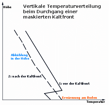
Masked cold front
During the sunny, cold last few days, a layer of cold air near the ground (inversion) has formed in many places due to night-time radiation. When the cold front arrives on Saturday, it will bring air masses from the Atlantic that may be warmer than this cold layer near the ground. As the front passes through, the layers will be mixed and the cold air on the ground will be cleared out. Overall, it is then warmer on the ground after the cold front than before, while the higher layers of air cool down. In this case, we speak of a masked cold front, because people typically located close to the ground only notice that it is getting warmer and that the cold front has thus successfully camouflaged itself. (Of course, meteorologists are not misled by such simple deceptive maneuvers!)