Skip to content

Cookies 🍪

This site uses cookies that need consent.

Learn more

Zur Powderguide-Startseite Zur Powderguide-Startseite
WeatherBlogs

WeatherBlog 3 2017/18 | Torsten is in a winter mood

Don't change a running system

by Lea Hartl 11/28/2017
The signs are still pointing to winter. A northerly current is carrying polar air masses towards the Alps. It's snowing and it's staying cold or getting colder, at least in Europe. If anyone is interested in the weather at the North Pole: it's getting warm there.

Low pressure system Torsten

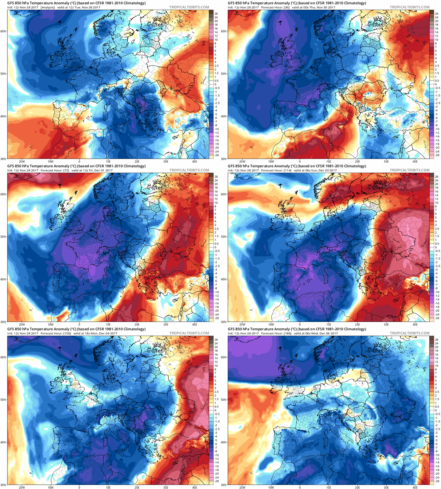
Cold polar air is being pushed into Central Europe on the western flank of a low-pressure trough with a core over Denmark. The main low pressure system responsible, Torsten, is pushing its cold front over the Alps today, behind which the cold air will gradually work its way to North Africa over the next few days. Temperatures will be around 10°C below the usual average for this time of year. The cold air will be transported to us via the North Sea and the North Atlantic, where it will be enriched with moisture on the one hand and warmed slightly on the other, as the water is still relatively warm. Snow is therefore scarce in the German lowlands. However, the small, medium and large elevations that stand in the way of Torsten's cold breath should get a blanket of white, or can be powdered with the existing base. Tomorrow, Thursday, a Vb-like marginal low pressure development in the upper Adriatic should provide snow in the eastern Austrian lowlands, which is interesting for skiing opportunities on the eastern edge of the Alps, but probably less pleasing for morning traffic in Vienna.

WeatherBlogs
presented by

Low Torsten's swim in the Mediterranean

So, as mentioned, Torsten makes it over the Alps with his cold air and into the not-so-sunny south. Nevertheless, when Torsten arrives on the Riviera, he immediately goes for a swim in the sea. He splashes around in the Gulf of Genoa for a while - the water is still so nice and warm at this time of year! At some point, he leaves again, leaving behind the warm sea and the memory of the passionate and unstable northerner. The result is a high-altitude cold cutoff low, i.e. a strong genoa low. The models are still relatively divided as to where exactly this low is heading. At the moment, it looks like a more southerly track and thus again potentially extreme amounts of rain in Greece and Albania. However, the southern slopes of the Alps are also likely to get a lot, as the Mediterranean low will continue to dominate the weather here over the weekend. We'll leave the details to our colleague Orakel.

Warm Arctic

As is the case with sloshing waves, whether air or water, Torsten's large-scale cold air wave also has another side and warm air from the south sloshes far to the north. In the polar region, there are similarly large temperature deviations from the average as in the Mediterranean region, but in the opposite direction. The sea ice extent is increasing in line with the season, but very slowly and the warm temperatures are of little help. The ice area is significantly smaller than average, although not as small as in 2016, when new negative records were set in November and December.

https://nsidc.org/arcticseaicenews/charctic-interactive-sea-ice-graph/

Medium-term

The generally wintry situation will persist until at least the weekend. The medium-term outlook is still uncertain. It won't stay as cold as the next few days for long, but a threatening onset of summer (why doesn't anyone ever say that? Do you just let summer in and winter has to break in?) is also not in sight. For the beginning of the week, it seems likely that the weather will be milder in the forest or, at low altitudes, slushy weather (technical term!) as the Atlantic high moves slightly to the west.

Photo gallery

ℹ️PowderGuide.com is nonprofit-making, so we are glad about any support. If you like to improve our DeepL translation backend, feel free to write an email to the editors with your suggestions for better understandings. Thanks a lot in advance!

Show original (German) Show original (French)

Related articles

Comments

WeatherBlogs
presented by