
Every year, we wish for reliable announcements that the winter will be great, preferably including a great forecast for the long weekend when the ski trip is already booked. Every year there is no such thing. This week's WeatherBlog deals with the following question from PG reader Benny_Supernova:
If you combine that (last week's polar vortex topic) with a 65% probability of an upcoming "El Nino" in the Northern Hemisphere winter, see here, what do you get when you put it all together? Yet another "hammer winter" in the Northern Alps (e.g. Innsbruck, where my best skiing buddy lives)?
A 65% probability for a weak El Nino is not a very spectacular probability. Apart from that, ENSO (El Niño Southern Oscillation) is much more decisive for North and South America than for Europe. The 2009/10 season was an El Niño winter and unusually cold in Europe. The extremely warm, dry 2006/07 season was also an El Niño year. (Here's an explanation of what El Niño actually is.)
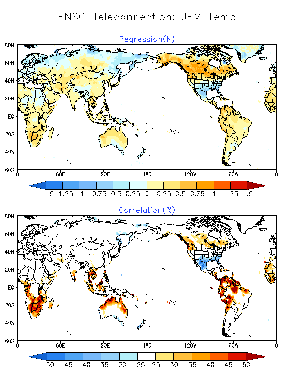
Of course, it's not quite that simple. This 1994 study based on observational data finds vague links between predominantly cyclonic weather in Europe during warm SE phases (El Niño) and anticyclonic weather during cold phases (La Niña), but points out that these links are not linear and can only be found using conditional probabilities and statistical mumbo-jumbo. This study from 2002 also finds significant correlations in terms of statistics, but it is not about "in the first week of January it snows three meters in Innsbruck", but rather about "in the western Mediterranean it may rain a little more in autumn". There are several other studies that analyze climate data in search of patterns of a connection between sea temperatures in the Pacific and the weather in Innsbruck (e.g. here). Most agree that there is some connection, except when there isn't. The following graphs show linear (!) correlations between ENSO and temperature and precipitation. The lower part shows the correlation in percent. Over Europe, this is 0 percent, i.e. no linear correlation.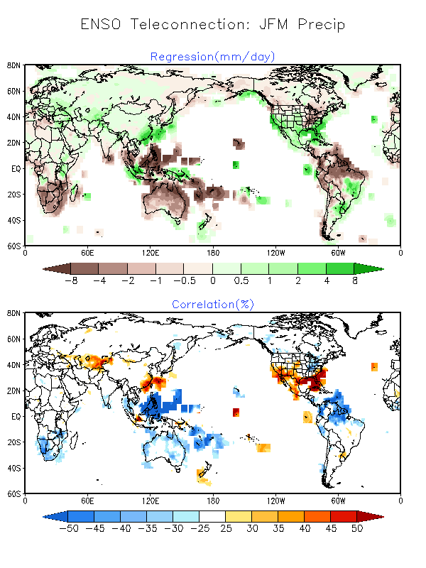
Model-based studies such as this one also assume a certain correlation, but they also come to the conclusion that it is difficult to find and even more difficult to understand, as identifiable signals of such so-called teleconnections are often smaller than the general noise. It's a bit like trying to calculate exactly when your best ski buddy will buy new skis based on the Dow Jones. It is somehow conceivable that the local economy is doing well when the American economy is doing well, and that he is more likely to make a purchase when the economic situation in the country is generally good, assuming that there is also snow. But it could also be that he gets money from his grandma for Christmas and the old ski has simply had too many coreshots. In this case, it would then be a matter of proving that the amount of grandma's Christmas money is related to the condition of the Down Jones, and if so, how, and whether your buddy buys a more expensive ski because he has more money or because the ski is better made and in general ...
Another question is the connection between ENSO and the stratosphere, or more generally the interaction between the troposphere (where our weather takes place) and the stratosphere (above it). There are model-based studies that come to the conclusion that during El Niño phases, quasi-stationary planetary waves in the troposphere propagate vertically into the stratosphere, where a so-called sudden stratospheric warming can then take place, which in turn weakens the polar vortex, which in turn is sometimes decisive for our weather.
Conclusion: From the summary, nothing at all emerges regarding a potential hammer winter in Innsbruck and long-term forecasts should be treated with caution. If you still want to look into such things, the WeatherBlog recommends the NAO (North Atlantic Oscillation) or the AO (Arctic Oscillation) Index instead of ENSO, as the correlations are clearer.
And what about the weather?
As most people will have noticed, the changeover to a westerly flow discussed last week has taken place and the boring dull weather has turned into mild and humid Atlantic weather, which looks like winter, at least at higher altitudes. Towards the weekend, the flow will shift somewhat and it will become foehn-like before a cold front, which is not too productive in terms of snow, moves through on Sunday. It will definitely be exciting in the British Isles, which will be hit hard by the extremely potent low pressure system Alexandra these days. http://www.weather.com/storms/winter/news/greenland-bomb-cyclone-iceland-uk-alexandra
From today's perspective, things may get interesting again in the Alps in the middle of next week, but as we know, a lot can still happen before then.
As usual, please send your topic requests for the weatherblog here http://www.powderguide.com/community/forum/post//themenwuensche-wetterblog/5.html
or on the PG facebook page.
