
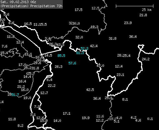
Last week it snowed 60 cm in 48 hours in Bregenz, the usually unexciting provincial capital of Vorarlberg, with 52 cm falling on February 8, with impressive precipitation rates of up to 13 mm/h. The spectacle was thanks to the legendary lake effect. You need a large body of water (say 100 km or more) that is not frozen. Otherwise, all you really need is cold air flowing over the comparatively warm water, as was the case at Lake Constance last week thanks to the north-westerly flow. The cold air absorbs moisture above the water and, depending on how large the vertical temperature gradient is, an increasingly unstable stratification develops. This means that the warm, moist air can rise from the water surface. It is colder at the top and the water contained in the warm air condenses and forms clouds. With strong lake effects, this can even lead to winter thunderstorms. The fun is limited locally, it can stay dry just a few kilometers away (see graphics)

Ocean Effect
Lake Constance is actually too small for proper lake effects, the whole thing only works there if the inflow is just right. The lake effect hot spot is probably the large lakes in the USA, e.g. Lake Ontario, where meters of lake water can snow onto the shore in just a few hours. The phenomenon is also typical at the Great Salt Lake in Utah. The effect can occur in exactly the same way over oceans or bays (it is then called the Ocean Effect), for example when Siberian air masses flow over the Sea of Japan and delight powder fans in Japan.
Nemo
On a side note, last weekend Nemo, the most severe blizzard since 1987 according to NOAA, caused unusual amounts of snow and associated chaos on the east coast of the USA. Compared to this, the weather here has been very unspectacular over the past week, although it hasn't been bad in terms of winter conditions - you could almost say it's been really good in the Nordstau and recently also in the Südstau. For the next few days, it still looks unspectacularly changeable, but there should be at least a bit of sunshine everywhere at the weekend. The further development is uncertain, but I wouldn't expect any PowderAlert-worthy events for the time being.


