It's hard to hear, but the meteorological winter is rapidly approaching its end. In terms of temperature, the past three months have been more or less average, with an above-average amount of snow and extremely few hours of sunshine. The astronomical seasons are based on the position of the sun (winter: winter solstice - spring equinox). The meteorological seasons make things easier for themselves and start on the first of the month in which the astronomical seasons also begin. Meteorologically speaking, December, January and February are the winter months, March, April and May are spring months and so on. This makes it much easier to carry out seasonal comparisons, as you can use the averages of entire months and do not have to laboriously calculate when, for example, the winter solstice was exactly (December 20 or 21) in order to then determine the corresponding values separately. In the meteorological winter of 2012/13, Austria only had 37% of the usual long-term average (1981-2010) hours of sunshine. Snow records were mainly set in the lowlands, for example in Vienna and Bregenz, although the higher altitudes were also well supplied with snow. Apart from extreme events such as the thaw at the turn of the year, temperatures were in the average range, with no periods of severe frost.

Season forecasts
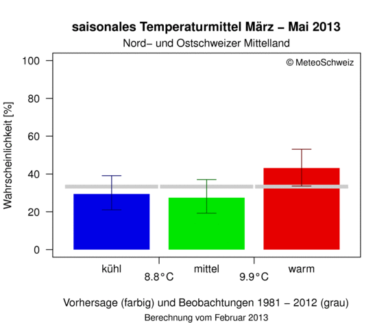
Winter may now be over, at least according to one of the possible definitions, but the upcoming spring is of course no less interesting from a skiing perspective. Various services are now making repeated attempts to produce season forecasts. The providers usually add a note to the results saying that they are by no means certain and that nobody should base their vacation plans on them (http://www.meteoschweiz.admin.ch/web/de/klima/klima_morgen/klimaausblick/klimaausblick_winter/saisonale_vorhersage_wi.html). Some media, on the other hand, are happy to announce a "hot summer" or something similar because someone has calculated that the next summer will be 55% warmer than the average of the last 30 years. (By the way, if you don't calculate but guess, this probability is 50%).

Trends and tendencies for larger areas are determined in long-term forecasts. It is not possible to determine in September whether it will snow on Christmas Eve in Munich-Schwabing. The most that can be said is whether it will be colder or wetter in Central Europe in the coming months than is usual on average. This is usually done using coupled ocean-atmosphere models, which use variables such as sea surface temperature, sea ice extent, snow cover and soil moisture to make certain statements based on statistical empirical values. In regions whose climate is strongly influenced by phenomena such as ENSO (el Niño/ la Niña), this works better than in this country, where weather conditions change more quickly and the "background noise" (= rapidly changing weather conditions) overlays other signals. Other approaches are based on analogy ("last summer the temperature and pressure distribution was the same as now, so this summer will be similar") or correlation principles ("because the pressure distribution in the northern hemisphere is like this at time X, it will be correspondingly different at time Y"). The better complex relationships are understood and the more powerful the dynamic ocean models in particular become, the better seasonal forecasts will be. Finally, a brief look at the less long-term outlook: The low pressure system in the south is losing influence and the sun should prevail more or less everywhere by the weekend, with some tough high fog persisting at lower altitudes. Top touring weather just in time for the start of spring!


