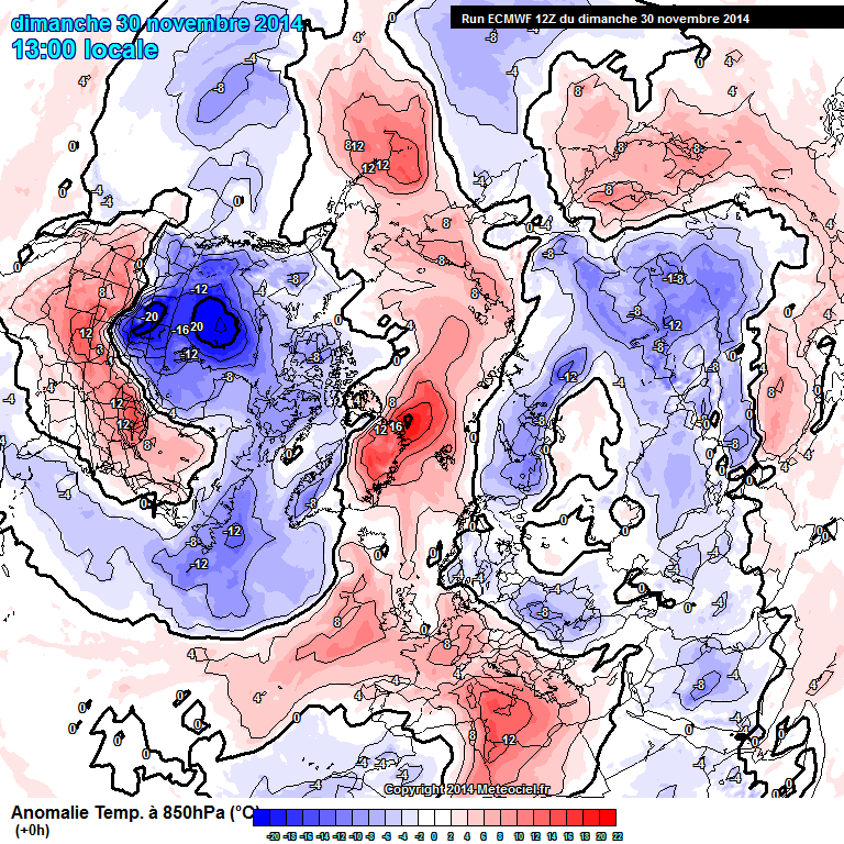
The WeatherBlog has been asked to explain why winter is "broken". We could go on for a while about what exactly broken means - broken in comparison to climatological averages or only in my subjective perception? Broken in general or just on my local mountain? And anyway, meteorologically speaking, it's only been winter for 3 days, so how are you supposed to know if something is broken? But we're not like that ...
Due to the very negative radiation balance, an altitude low forms over the respective winter pole in winter - the polar vortex that has already been mentioned a lot here. Over the Arctic, the polar vortex often has a dipole-like structure with two centers due to the uneven land/water distribution. In the Antarctic, it is rounder and more long-lived, as the pole is surrounded by water and there are no land masses in the way of the westerly winds. A "healthy" polar vortex is as round as possible and is orbited by a jet that runs zonally and has only a few, weakly pronounced waves. In our latitudes, this typically means Atlantic weather with a moist, not too cold westerly or northwesterly current and a rapid succession of smaller marginal lows.
A "disturbed" polar vortex creates many, pronounced waves, is not particularly round and looks like a splash of color from a comic book. The westerly drift is often blocked and weather patterns can persist for a long time. Depending on where you are in the wave, it is either very cold or very warm for a long time, or you swim in the spray at the edge of the wave, so to speak, and get one storm after another.
For some time now, a high over Eastern Europe has been decisive for us, pushing the frontal zone of the jet far to the north and allowing lows to pass only south of the Alps in the Mediterranean region.
As the pressure contrasts between the pole and the rest of the world become smaller with an increasingly warm Arctic in winter, the polar vortex is theoretically also weakened. This has prompted speculation that a warmer climate could lead to more frequent winter weather patterns (in both directions) due to "disturbed" circulation. The emphasis here is on "speculation". Definitive statements on long-term climatic developments cannot be made on the basis of one or two winters, nor on the basis of 10 winters in terms of meaningful statistics.


