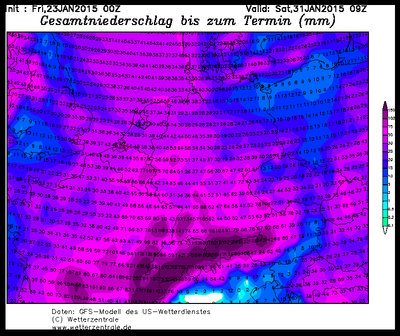
Just in time for the weekend, the floodgates open and Ullr lets out powder for all the starving northern Alps. Most in the west, least in the east and almost nothing in the south this time. Except for Slovenia and Carinthia, which benefit from a southerly flow in the east. But there is no monster dump. That's because our low-pressure complex has moved too far to the west and therefore the current in the Alps has shifted from the previously forecast north to west and the snow bear is now tapping in the Pyrenees.
The whole thing comes with strong storms and cold and will lead to rather unfriendly whiteout conditions and massive drifts above the tree line by Saturday morning. But since it will stay cold, all the snow will be sheltered from the wind as powder almost all the way down, so that in the regions in the west where there is some base above 1000 m, you can finally unpack your snorkel in the forest.
How much is coming?
From the deep east to Tyrol there will be 20 to 40 cm on the soft base, but there is more potential for surprises at the bottom than at the top, especially in the far east.
From the Arlberg to the Berner Oberland I see 40 to 70 cm of powder, but I don't think the magic meter will be cracked. If so, then only in the one jam hole where the west jam can reach through or the system will come further east.
From the Unterwallis to northern France in the Haute Savoy is the zone where Ullr distributes powder with the coarse trowel and here it can be a good 80 to 110 cm with potential of up to 20 or 30 cm extra in west jams. However, I think that the one meter is more likely than the one and a half.
This is followed to the south by a zone with 60 to 90 cm in the west jam up to the Hautes Alpes, but surprises are also possible here in jam holes upwards of 10 to 20 cm.
The whole amounts will reach through to the main ridge in the west jam and a few cm will even go beyond that due to the strong current. In the "real" south, only about 20 to 50 cm are possible in Carinthia and Slovenia, as the current of the low is coming from the south.
Whether the white wizard will come in part two and bring even more powder reinforcement to the battle on the Breitlatten Pass will be clarified on Saturday when you tune in to your favorite premium blog again. In general, thanks to Ullr, it will remain cold with the potential for snowfall until well into the medium term.
Where should I go? If you want to go really deep, of course to Unterwallis or France, everyone else can let off steam in their favorite tree area, only in the east will it be nice rather than over-b-e-r-k-r-a-s-s-GO-Pro-DEEP! But you shouldn't bet on sunshine, because although there might be a few minutes of sunshine here and there on Saturday, the weather will tend to be cloudy until Monday. You're most likely to see the sun in the areas with the least fresh snow, i.e. in the north-east of the Alps.
So saddle up your horsepower and ride towards Helm's Deep!
Powder to the people!
Your Oracle


