
A strong Azores high will bring a northerly flow to the Alpine region. This will bring wintry temperatures and precipitation. Where exactly the latter will end up is still somewhat uncertain
.
Current situation
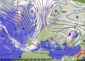
For a change, the Alps are in a northerly flow and it has dried up for the time being. On Wednesday (22.1.14), between yesterday's and tomorrow's disturbance, an intermediate high made itself felt and it was largely sunny everywhere, with the exception of a few tenacious patches of high fog. This is rather unusual this season: it was not only sunny, but also quite cold, or rather normal-cold for the time of year. We have continental air masses to thank for this, which are working their way towards us from the north-east. They are able to do this because our western highway, which we have already discussed several times, has been caused to lurch a little by a strengthened Azores high.
Outlook
The tension is rising. Certain ski resorts known to the WeatherBlog, which have not been able to make snow since Christmas and are only saving a strip of valley run through the green meadows thanks to the art of the snow groomer drivers, are hoping that they will be able to fire up their snow cannons again at the end of the week. After all, both a piste ski touring race and a Klumper competition are coming up, and when it gets to the point in Tyrol where not only the local mountain edge is bare and freeride contests are postponed, but you even have to worry about the drunker niche types of tobogganing - is Tyrol still Tyrol at all? But it will be, luckily. At least it will probably be cold enough to produce artificial snow at low altitudes and we can also assume that it will snow for real. The decisive factor for the further development is a small shortwave trough (a smaller wave embedded in the larger ones), which is preparing to drift from the North Atlantic into the Mediterranean region as a smaller low. A user of the skywarn.at forum has drawn the movement of the shortwave trough very nicely here:


The maps show the predicted development from Wednesday to Friday. Note how fast the small wave is moving! From Newfoundland to the Mediterranean in three days is quite remarkable. The exact path of this upcoming low pressure system will determine the location of the main areas of precipitation from Friday. At the moment, it looks like the eastern southeast side of the Alps and the Balkans.
In concrete terms
The northern side of the Alps will be rather cloudy on Thursday and Friday with the onset of snowfall from a more or less heavy disturbance (purple line in the analysis map above). There should be a bit of a mix, but we'll leave the details to our colleague the oracle if the worst comes to the worst. The weekend and the beginning of next week will also tend to remain unsettled with further potential for snow in the north and wintry temperatures thanks to the persistent northerly flow. In terms of volume, the developing Mediterranean low and the really eastern south-east are currently the most interesting, but a continuous migration of small animals in the previously dry north should improve the situation there somewhat.


